
UND scientists study glacial melt
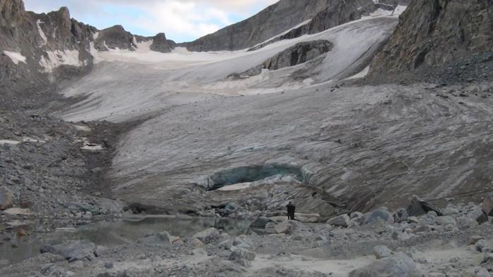
The Knife Point Glacier is one of many glaciers scientists are studying in Wyoming. Photo by Jeff VanLooy
UND students and instructors have been hiking up glaciers deep in mountainous Wyoming to study the intricacies of glacial melting.
Groups of undergraduate and graduate students from multiple disciplines intern every summer to study glaciers in the Wind River Range of Wyoming. Earth system science and policy assistant professor Jeff VanLooy and Greg Vandeberg, an associate professor from the geography department, have been studying glaciers from the Wind River Range since 2011.
“The wind river range has one of the largest glacial masses of any range in the Rocky Mountains of the lower 48,” VanLooy said.
The Wind River Range is larger than Glacier National Park but smaller than some Alaskan glaciers.
VanLooy went on to talk about the challenges of getting to the research sites.
“There hasn’t been a whole lot of research there, especially on the ground because it’s so difficult to get to,” he said.
The Wind River Range is strictly a no motorized vehicle area. Getting to the glaciers is a 16-mile horseback ride up steep terrain followed by a two-day hike up to 12,000 feet to arrive at some of the research locations.
“We’re carrying everything on our backs for 10 days — all of our food, our survival gear and the research equipment. We’re in the middle of a wilderness area, so there’s no easy fix if someone were to get hurt,” Vandberg said.
Altitude sickness is also a concern at 12,000 feet.
“You’re always cold, no matter how many layers of clothing you have on — it seems you’re always cold, hungry and
exhausted,” Vandeberg said.
Aerial topographic maps of the glaciers have been recorded since the ‘60s. These maps measure the surface area of the glaciers. VanLooy and Vandeberg are able to measure the ice thickness over time by using an ice radar and dragging it across the surface of the glaciers. The benefits of being on the glacier include recording the volume of each glacier.
“With that volume we can apply how quickly the glacier is melting to get a sense of how long the glacier will be around as a water resource,” VanLooy said. “What we’re finding about the melt rate is that it varies from glacier to glacier.”
Glaciers at lower elevations that are in the open will melt faster than glaciers with ridge protection at a higher elevation.
“The glaciers are melting two to three times faster over the last 16 years when compared to the last 30,” VanLooy said.
He predicts that within 50 years the glaciers in the Wind River Range will be half their present size, and that in 100 years the
glaciers could melt away completely.
“The people who live downstream of the glacier depend on snow and glacial melt as a water resource,” VanLooy said. “There’s around 72 million cubic meters of ice on Continental Glacier now. If you melt Continental Glacier, it will cover all of Grand Forks in 4 feet of water.”
That’s 17 billion gallons of water that could come from the melted ice in less than 100 years if conditions continue.
VanLooy and Vandeberg would like to thank the U.S. Forest Service, the Greater Yellowstone Coordinating Committee and the Bridger-Teton National Forest for their assistance in this research.
“The adventure comes in when you go into these deep wilderness areas where the Wind River Range is located. When you have downtime and you’re relaxing, looking around at the scenery, it’s absolutely spectacular,” Vandeberg said. “When you’re up there, you’re thinking, ‘gosh I can’t wait until this is over,’ then when you’re done, you’re like, ‘I wish I was still back up there,’” Vandeberg said.
Nick Sallen is the opinion editor for The Dakota Student. He
can be reached at [email protected]